


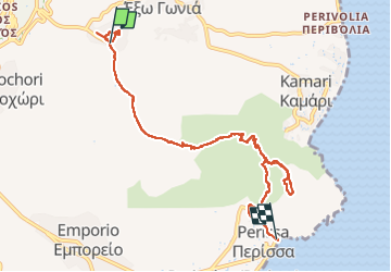
SANTORIN - Pyrgos - Perissa - GRECE

Michel1963
User GUIDE

Length
9.4 km

Max alt
537 m

Uphill gradient
378 m
Km-Effort
15.5 km

Min alt
0 m

Downhill gradient
696 m
Boucle
No
Creation date :
2024-05-28 08:28:42.568
Updated on :
2024-05-28 13:02:37.519
4h19
Difficulty : Medium

FREE GPS app for hiking
 SityTrail
IGN / Geographical institutes
SityTrail Plus
The world is yours!
About
Trail Walking of 9.4 km to be discovered at Aegean, Thira Regional Unit, Thira Municipal Unit. This trail is proposed by Michel1963.
Photos


39 photos in total. Please click on a photo to see them all in the gallery.
Positioning
Country:
Greece
Region :
Aegean
Department/Province :
Thira Regional Unit
Municipality :
Thira Municipal Unit
Location:
Unknown
Start:(Dec)
Start:(UTM)
360938 ; 4027470 (35S) N.
Comments